
")
")


Pilastro Lomasti
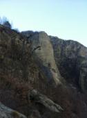
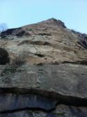
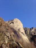

Interesting rock climbing area for routes from 6a to 6c and from 7a to 7c (french grades).
Best time(s) :
- January
- February
- March
- April
- May
- June
- July
- August
- Sept.
- Oct.
- Nov.
- Dec.
Aspect(s) : SW Altitude : 1050 m
Approach 45 min up hill then down hill. Kids friendly ? foot of the crag uneven for young kids.
Informations :
Between 10 and 25 routes, from 6a to 7b. Bolting : sport climbing
Max Height : 200 m.
Rock :
gneiss. Characteristic(s) : steep wall  , vertical
  . Type(s) of holds : pockets / holes, crimps, slopers.
We liked this/these route(s) : Sylvie + la rossa e il Vampirla + vertiggine
Locations :
Area :
Italy, Valle d'Aosta, Provincia di Aosta, Aosta, Arnad.
|
|
Latitude : 45° 37' 42" N | Longitude : 7° 44' 48" E | Sexagesimal & Orientation |
|
|
Latitude : 45° 38' 16" N | Longitude : 7° 44' 18" E | Sexagesimal & Orientation |
| More coordinates |
Area added by Alberto Boschiazzo


