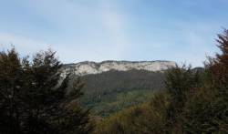
Pène Haute
Interesting rock climbing area for routes from 6a to 6c, from 7a to 7c and starting from 8a (french grades).
![Information](/images/attention.png)
Many additional skills about progressing, belaying, escaping technics ... are necessary for multipitch routes security.
Best time(s) : - January
- February
- March
- April
- May
- June
- July
- August
- Sept.
- Oct.
- Nov.
- Dec.
Aspect(s) : S-E Altitude : 1350 m
Approach 15 min up hill. Kids friendly ? foot of the crag uneven for young kids.
Informations :
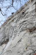
More than 200 routes, from 4c to 8c. Bolting : sport climbing
Max Height : 120 m.
Rock :
limestone.
Characteristic(s) : slab
![Dalle](/images/dalle.png)
, vertical
![Vertical](/images/vertical.png)
, steep wall
![Dévers](/images/legerdevers.png)
.
Type(s) of holds : crimps.
Locations :
Area :
France, Occitanie, Hautes-Pyrénées (65), Lannemezan, Sarrancolin.
![Information](/images/readme.png)
1. Zoom in to get all the rock climbing places 200 km around.
![](/images/mm_20_green.png)
: Bouldering
![](/images/mm_20_orange.png)
: Single pitch
![](/images/mm_20_red.png)
: Multi pitches
![](/images/mm_20_blue.png)
: Deep water soloing
![](/images/mm_20_white.png)
: Differents kind of climbing
Rock climbing area GPS Coordinates : |
Latitude : 43° 0' 0" N |
Longitude : 0° 24' 51" E |
Sexagesimal & Orientation
|
|
Latitude : 43° 0' 0" |
Longitude : 0° 24' 51" |
Degrees, Minutes, Seconds (DMS)
|
|
Latitude : 43° 0.014' |
Longitude : 0° 24.853' |
Degrees, Décimal minutes (DM)
|
|
Latitude : 43.000238° |
Longitude : 0.414219° |
Decimal degrees (DD)
|
|
Parking lot GPS Coordinates : |
Latitude : 42° 59' 43" N |
Longitude : 0° 25' 15" E |
Sexagesimal & Orientation
|
|
Latitude : 42° 59' 43" |
Longitude : 0° 25' 15" |
Degrees, Minutes, Seconds (DMS)
|
|
Latitude : 42° 59.73' |
Longitude : 0° 25.251' |
Degrees, Décimal minutes (DM)
|
|
Latitude : 42.995499° |
Longitude : 0.420849° |
Decimal degrees (DD)
|
VIDEOS
Area added by CA