
")
")


Parc de la commune de Paris (Cusset)
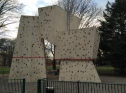
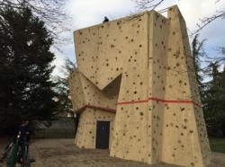
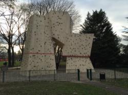
Interesting rock climbing area for routes up to 5c and from 6a to 6c (french grades).
Aspect(s) : All Altitude : 150 m
Approach 2 min easy down hill then easy up hill. Kids friendly ? foot of the crag comfortable for young kids.
Informations :
Between 10 and 25 routes, from 3a to 6c. Bolting : sport climbing
Max Height : 8 m.
Rock :
plastic. Characteristic(s) : vertical  , slab
  . Type(s) of holds : jugs, pockets / holes, crimps, water erosion pockets, cracks, slopers.
Web site(s) :
http://www.ffme.fr/site/sae-fiche/3655.html
Locations :
Area :
France, Auvergne-Rhône-Alpes, Rhône (69), Lyon, Villeurbanne, Cusset.
|
|
Latitude : 45° 46' 8" N | Longitude : 4° 54' 6" E | Sexagesimal & Orientation |
|
|
Latitude : 45° 46' 8" N | Longitude : 4° 54' 8" E | Sexagesimal & Orientation |
| More coordinates |
Area added by La paupiette

