
")
")


Orbeil

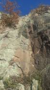
Interesting rock climbing area for routes from 6a to 6c (french grades).
Best time(s) :
- January
- February
- March
- April
- May
- June
- July
- August
- Sept.
- Oct.
- Nov.
- Dec.
Aspect(s) : SW-S Altitude : 400 m
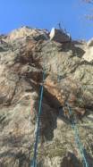
Approach 2 min steep up hill. Kids friendly ? foot of the crag uneven for young kids.
Informations :
Between 10 and 25 routes, from 3c to 7c+. Bolting : big run out climbing, sport climbing
Max Height : 35 m.
Rock :
granite. Characteristic(s) : slab  . Type(s) of holds : crimps.
Web site(s) :
https://www.ffme.fr/sne-fiche/1502/
Locations :
Area :
France, Auvergne-Rhône-Alpes, Puy-de-Dôme (63), Issoire, Orbeil.
|
|
Latitude : 45° 34' 20" N | Longitude : 3° 15' 7" E | Sexagesimal & Orientation |
|
|
Latitude : 45° 34' 20" N | Longitude : 3° 15' 5" E | Sexagesimal & Orientation |
| More coordinates |
Area added by guillaume gaime

