
")
")


Old Man of Hoy
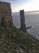


Interesting rock climbing area for routes from 7a to 7c (french grades).
Best time(s) :
- January
- February
- March
- April
- May
- June
- July
- August
- Sept.
- Oct.
- Nov.
- Dec.
Aspect(s) : All
Approach 30 min by boat. Kids friendly ? foot of the crag dangerous for young kids.
Informations :
Less than 10 routes, from E1 5a/b to E6 6b. Bolting : traditionnal climbing
Max Height : 150 m.
Rock :
sandstone. Characteristic(s) : vertical  . Type(s) of holds : crimps, slopers.
Further information(s) : First climbed in 1966 by Chris Bonington, Rusty Baillie and Tom Patey over 3 days.
Locations :
Area :
United Kingdom, Scotland, Orkney Islands, Hoy island, Rackwick.
|
|
Latitude : 58° 53' 10" N | Longitude : 3° 25' 50" W | Sexagesimal & Orientation |
|
|
Latitude : 58° 52' 24" N | Longitude : 3° 23' 6" W | Sexagesimal & Orientation |
| More coordinates |
Area added by quelqu'un qui n'a pas laissé son nom :)


