
")
")


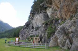
Oberried
Interesting rock climbing area for routes up to 5c and from 6a to 6c (french grades).
Best time(s) :
- January
- February
- March
- April
- May
- June
- July
- August
- Sept.
- Oct.
- Nov.
- Dec.
Aspect(s) : E Altitude : 1200 m
Approach 5 min on flat ground. Kids friendly ? foot of the crag comfortable for young kids.
Informations :
Between 25 and 50 routes, from 3a to 7c , spread over 3 crags Bolting : sport climbing
Max Height : 25 m.
Rock :
gneiss. Characteristic(s) : slab  , vertical
  , steep wall
  , overhang
  , dihedral
  . Type(s) of holds : underclings, jugs, crimps, cracks, slopers.
Web site(s) :
http://www.climbers-paradise.com/klettern/location-details/location/sportklettern/oetztal/oberried/
Locations :
Area :
Austria, Land Tirol, Bezirk Imst, Innsbruck, Längenfeld.
|
|
Latitude : 47° 4' 33" N | Longitude : 10° 57' 4" E | Sexagesimal & Orientation |
|
|
Latitude : 47° 4' 41" N | Longitude : 10° 56' 56" E | Sexagesimal & Orientation |
| More coordinates |
Area added by Gaseur


