
")
")


Monte Latu
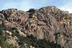
single pitch routes and multi pitch routes rock climbing area
Best time(s) :
- January
- February
- March
- April
- May
- June
- July
- August
- Sept.
- Oct.
- Nov.
- Dec.
Aspect(s) : W-SW Altitude : 650 m
Approach 15 min up hill
Rock :
granite. Characteristic(s) : vertical  , slab
  . Type(s) of holds : jugs, crimps, slopers.
Informations :
Single pitch routes
Between 10 and 25 routes, from 3c to 6c. Bolting : sport climbing.
Max Height : 30 m.
Kids friendly ? foot of the crag reasonable for young kids.
Multi pitch routes
Less than 10 routes, from 6a to 6b. Bolting : big run out climbing.
Max Height : 200 m.
Kids friendly ? foot of the crag dangerous for young kids.
Locations :
Area :
France, Corse, Corse-du-Sud (20), Ajaccio, Ocana.
|
|
Latitude : 41° 57' 42" N | Longitude : 8° 57' 32" E | Sexagesimal & Orientation |
|
|
Latitude : 41° 57' 49" N | Longitude : 8° 57' 33" E | Sexagesimal & Orientation |
| More coordinates |
Area added by CA


