Mont Oreb
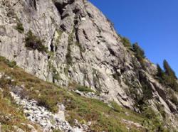
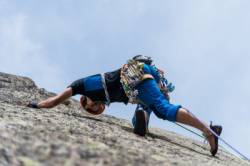
Interesting rock climbing area for routes from 7a to 7c (french grades).
![Information](/images/attention.png)
Many additional skills about progressing, belaying, escaping technics ... are necessary for multipitch routes security.
Best time(s) : - January
- February
- March
- April
- May
- June
- July
- August
- Sept.
- Oct.
- Nov.
- Dec.
Aspect(s) : S Altitude : 2500 m
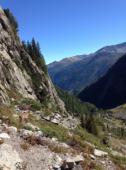
Approach 1h15 min up hill. Kids friendly ? foot of the crag dangerous for young kids.
Informations :
Between 10 and 25 routes, from 5c to 6a. Bolting : traditionnal climbing, sport climbing
Max Height : 600 m.
Rock :
gneiss.
Characteristic(s) : slab
![Dalle](/images/dalle.png)
.
Type(s) of holds : crimps.
Locations :
Area :
France, Auvergne-Rhône-Alpes, Haute-Savoie (74), Chamonix, Vallorcine.
![Information](/images/readme.png)
1. Zoom in to get all the rock climbing places 200 km around.
![](/images/mm_20_green.png)
: Bouldering
![](/images/mm_20_orange.png)
: Single pitch
![](/images/mm_20_red.png)
: Multi pitches
![](/images/mm_20_blue.png)
: Deep water soloing
![](/images/mm_20_white.png)
: Differents kind of climbing
Rock climbing area GPS Coordinates : |
Latitude : 46° 1' 4" N |
Longitude : 6° 52' 49" E |
Sexagesimal & Orientation
|
|
Latitude : 46° 1' 4" |
Longitude : 6° 52' 49" |
Degrees, Minutes, Seconds (DMS)
|
|
Latitude : 46° 1.077' |
Longitude : 6° 52.822' |
Degrees, Décimal minutes (DM)
|
|
Latitude : 46.017956° |
Longitude : 6.880367° |
Decimal degrees (DD)
|
|
Parking lot GPS Coordinates : |
Latitude : 46° 1' 7" N |
Longitude : 6° 55' 11" E |
Sexagesimal & Orientation
|
|
Latitude : 46° 1' 7" |
Longitude : 6° 55' 11" |
Degrees, Minutes, Seconds (DMS)
|
|
Latitude : 46° 1.122' |
Longitude : 6° 55.196' |
Degrees, Décimal minutes (DM)
|
|
Latitude : 46.0187° |
Longitude : 6.91994° |
Decimal degrees (DD)
|
Area added by Gilles & CA