
")
")


Marée
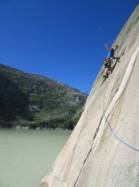
Interesting rock climbing area for routes from 6a to 6c (french grades).
Best time(s) :
- January
- February
- March
- April
- May
- June
- July
- August
- Sept.
- Oct.
- Nov.
- Dec.
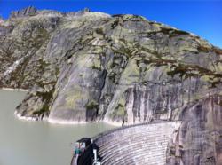
Aspect(s) : S Altitude : 1900 m
Approach 15 min easy down hill then easy up hill. Kids friendly ? foot of the crag dangerous for young kids.
Informations :
Between 10 and 25 routes, from 6b to 7a. Bolting : big run out climbing
Max Height : 150 m.
Rock :
granite. Characteristic(s) : slab  . Type(s) of holds : crimps, cracks, slopers.
Further information(s) : Bei hohem Wasserstand kann über die "HWT (High Water Traverse) Route" beim grünen Grasband eingestiegen werden.
Locations :
Area :
Switzerland, Bern, Verwaltungskreis Interlaken-Oberhasli, Interlaken, Guttannen.
|
|
Latitude : 46° 34' 21" N | Longitude : 8° 19' 41" E | Sexagesimal & Orientation |
|
|
Latitude : 46° 34' 17" N | Longitude : 8° 19' 55" E | Sexagesimal & Orientation |
| More coordinates |
Area added by Raglu 3411


