")
")


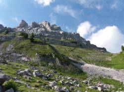
Les Piliers de la Pointe du Midi (ou Pointe Dzerat)
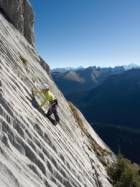
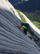
Interesting rock climbing area for routes from 7a to 7c (french grades).
Best time(s) :
- January
- February
- March
- April
- May
- June
- July
- August
- Sept.
- Oct.
- Nov.
- Dec.
Aspect(s) : S-SE Altitude : 2000 m
Approach 1h20 min steep up hill. Kids friendly ? foot of the crag dangerous for young kids.
Informations :
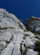
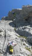
Between 10 and 25 routes, from 5c to 7a. Bolting : sport climbing
Max Height : 280 m.
Rock :
limestone. Characteristic(s) : vertical  , slab
  . Type(s) of holds : crimps, limestone channels.
Further information(s) : Accès de la majorité des voies par le col en 1h20.
Locations :
Area :
France, Auvergne-Rhône-Alpes, Haute-Savoie (74), Annecy, Le Reposoir.
|
|
Latitude : 46° 0' 8" N | Longitude : 6° 28' 47" E | Sexagesimal & Orientation |
|
|
Latitude : 45° 59' 31" N | Longitude : 6° 28' 30" E | Sexagesimal & Orientation |
| More coordinates |
Area added by CA