
")
")


Les Auvernes
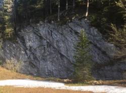
Interesting rock climbing area for routes from 6a to 6c (french grades).
Best time(s) :
- January
- February
- March
- April
- May
- June
- July
- August
- Sept.
- Oct.
- Nov.
- Dec.
Aspect(s) : W Altitude : 1200 m
Approach 5 min up hill
Informations :
Between 10 and 25 routes, from 6b to 7b. Bolting : sport climbing
Max Height : 12 m.
Rock :
limestone. Characteristic(s) : vertical  , steep wall
  . Type(s) of holds : pockets / holes, slopers.
Locations :
Area :
France, Bourgogne-Franche-Comté, Jura (39), Lons-le-Saunier, Lamoura.
|
|
Latitude : 46° 25' 4" N | Longitude : 6° 0' 28" E | Sexagesimal & Orientation |
|
|
Latitude : 46° 25' 9" N | Longitude : 6° 0' 25" E | Sexagesimal & Orientation |
| More coordinates |
Area added by CA


