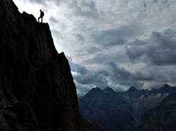
L'Aiguille Dibona
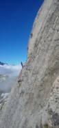
Interesting rock climbing area for routes from 7a to 7c and starting from 8a (french grades).
![Information](/images/attention.png)
Many additional skills about progressing, belaying, escaping technics ... are necessary for multipitch routes security.
Best time(s) : - January
- February
- March
- April
- May
- June
- July
- August
- Sept.
- Oct.
- Nov.
- Dec.
Aspect(s) : All Altitude : 3000 m
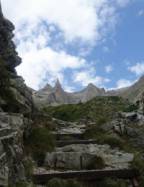
Approach 60 min steep up hill. Kids friendly ? foot of the crag dangerous for young kids.
Informations :
Between 10 and 25 routes, from 4a to 8a. Bolting : traditionnal climbing, sport climbing
Max Height : 400 m.
Rock :
granite.
Characteristic(s) : slab
![Dalle](/images/dalle.png)
, vertical
![Vertical](/images/vertical.png)
.
Type(s) of holds : crimps, cracks.
Locations :
Area :
France, Auvergne-Rhône-Alpes, Isère (38), Grenoble, Les Étages.
![Information](/images/readme.png)
1. Zoom in to get all the rock climbing places 200 km around.
![](/images/mm_20_green.png)
: Bouldering
![](/images/mm_20_orange.png)
: Single pitch
![](/images/mm_20_red.png)
: Multi pitches
![](/images/mm_20_blue.png)
: Deep water soloing
![](/images/mm_20_white.png)
: Differents kind of climbing
Rock climbing area GPS Coordinates : |
Latitude : 44° 57' 47" N |
Longitude : 6° 14' 36" E |
Sexagesimal & Orientation
|
|
Latitude : 44° 57' 47" |
Longitude : 6° 14' 36" |
Degrees, Minutes, Seconds (DMS)
|
|
Latitude : 44° 57.798' |
Longitude : 6° 14.602' |
Degrees, Décimal minutes (DM)
|
|
Latitude : 44.963295° |
Longitude : 6.243367° |
Decimal degrees (DD)
|
|
Parking lot GPS Coordinates : |
Latitude : 44° 56' 14" N |
Longitude : 6° 15' 17" E |
Sexagesimal & Orientation
|
|
Latitude : 44° 56' 14" |
Longitude : 6° 15' 17" |
Degrees, Minutes, Seconds (DMS)
|
|
Latitude : 44° 56.244' |
Longitude : 6° 15.289' |
Degrees, Décimal minutes (DM)
|
|
Latitude : 44.937401° |
Longitude : 6.25481° |
Decimal degrees (DD)
|
Area added by CA