
")
")


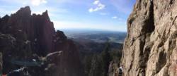
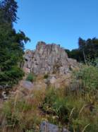
Kandelfels
Interesting bouldering area for problems from 6a to 6c and from 7a to 7c (Fontainebleau grades).
Best time(s) :
- January
- February
- March
- April
- May
- June
- July
- August
- Sept.
- Oct.
- Nov.
- Dec.
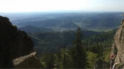
Aspect(s) : W-SW-S-NE Altitude : 1050 m
Approach between 15 and 20 min steep down hill then steep up hill. Kids friendly ? area around the boulders dangerous for young kids.
Informations :
Between 50 and 100 problems, from 3 to 9. Bolting : sport climbing
Max Height : 60 m.
Rock :
gneiss. Characteristic(s) : overhang  , vertical
  , slab
  . Type(s) of holds : crimps.
Landing quality : uneven or steep ground (1 crash pad and 1 spotter needed).
Locations :
Area :
Germany, Baden-Württemberg, Regierungsbezirk Freiburg, Waldkirch.
|
|
Latitude : 48° 3' 54" N | Longitude : 8° 0' 23" E | Sexagesimal & Orientation |
|
|
Latitude : 48° 4' 1" N | Longitude : 8° 0' 18" E | Sexagesimal & Orientation |
| More coordinates |
Area added by Maximilian Kleis


