
")
")


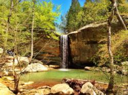
Jackson Falls
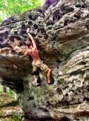


Interesting rock climbing area for routes from 6a to 6c and from 7a to 7c (french grades).
Best time(s) :
- January
- February
- March
- April
- May
- June
- July
- August
- Sept.
- Oct.
- Nov.
- Dec.
Aspect(s) : All Altitude : 150 m
Approach between 5 and 10 min steep down hill. Kids friendly ? foot of the crag comfortable for young kids.
Informations :
More than 400 routes, from 5.5 to 5.13c , spread over many crags Bolting : sport climbing
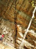
Max Height : 20 m.
Rock :
sandstone. Characteristic(s) : slab  , vertical
  , steep wall
  , dihedral
  . Type(s) of holds : jugs, pockets / holes, cracks, slopers.
We liked this/these route(s) : Group Therapy 5.10c
Legendary route(s) : East of East St. Louis 5.13b
Further information(s) : Located in the Shawnee National Forrest. This is high quality rock!
Note that it is possible to rappel down in some places as opposed to taking the otherwise lengthy approach.
Directly by the parking location given (which is just a gravel road to pull over on) you will find a camp site. Across the road from this is a trail. Follow it. You will come to rocks to hike over. Watch out. I have seen many the experienced person slip. The trail continues at the end of these rock slabs you are walking on, and this will be near where the slabs end, at a waterfall. Continue the trail. you will come to a bunch of boulders. Turn right onto them and go down the established little path thing down them. Again, be careful. You will go through a tunnel like thing between boulders. You are now in the classic "Reefer Madness" area. There is great bouldering here. If you follow any of the trails around, you will find great trad routes and bolted sport routes.
Be careful on the approach. The beginning is a fairly treacherous steep downhill scramble, right beside the first waterfall and the Chancellor Highball (V4). I've seen a man take a nasty tumble down the 30-foot falls so be careful! The stream can be very slippery. There is no cell service.
Often there are an over-abundance of ticks.
Often there are an over-abundance of ticks.
Web site(s) :
http://www.mountainproject.com/v/jackson-falls/106017458 http://www.rockclimbing.com/routes/North_America/United_States/Illinois/South/Jackson_Falls__Climbing_Routes_/ http://www.summitpost.org/jackson-falls/353634
Locations :
Area :
United States, Illinois, Pope County, Marion, Harrisburg / Ozark.
|
|
Latitude : 37° 30' 17" N | Longitude : 88° 41' 22" W | Sexagesimal & Orientation |
|
|
Latitude : 37° 30' 39" N | Longitude : 88° 40' 56" W | Sexagesimal & Orientation |
| More coordinates |
Area added by Jake Starr


