")
")


Ith - Lüerdissen
Interesting rock climbing area for routes up to 5c, from 6a to 6c and from 7a to 7c (french grades).
Best time(s) :
- January
- February
- March
- April
- May
- June
- July
- August
- Sept.
- Oct.
- Nov.
- Dec.
Aspect(s) : W-SW Altitude : 350 m
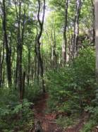
Approach 5 min on flat ground. Kids friendly ? foot of the crag comfortable for young kids.
Informations :
More than 300 routes, from 3a to 7c , spread over many crags Bolting : sport climbing
Max Height : 35 m.
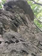
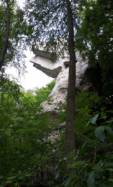
Rock :
limestone. Characteristic(s) : overhang  , steep wall
  , vertical
  . Type(s) of holds : pockets / holes, cracks, slopers.
Further information(s) : A user wrote about this crag:
This school is more for classic climbers than sport climbers.
This school is more for classic climbers than sport climbers.
Please use the official way's and don't step on the top of the rocks.
Web site(s) :
http://kletternimnorden.de/
Locations :
Area :
Germany, Niedersachsen, South, Alfeld, Lüerdissen.
|
|
Latitude : 51° 57' 57" N | Longitude : 9° 38' 31" E | Sexagesimal & Orientation |
|
|
Latitude : 51° 57' 47" N | Longitude : 9° 38' 49" E | Sexagesimal & Orientation |
| More coordinates |
Area added by Scholz, Torsten, exolon