
")
")


Heidenpfeiler (Südpfalz)
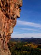
Interesting rock climbing area for routes from 7a to 7c and starting from 8a (french grades).
Best time(s) :
- January
- February
- March
- April
- May
- June
- July
- August
- Sept.
- Oct.
- Nov.
- Dec.
Aspect(s) : S Altitude : 350 m
Approach 15 min up hill. Kids friendly ? foot of the crag dangerous for young kids.
Informations :
Between 25 and 50 routes, from 5c to 7c. Bolting : big run out climbing
Max Height : 60 m.
Rock :
sandstone. Characteristic(s) : dihedral  , overhang
  , vertical
  , slab
  .
.
Legendary route(s) : HimmelsleiterVI+ E2 ; TopspinVIII- E1
Web site(s) :
http://www.pfaelzer-kletterer.de/
Locations :
Area :
Germany, Rheinland-Pfalz, South, Dahn, Busenberg.
|
|
Latitude : 49° 6' 53" N | Longitude : 7° 50' 12" E | Sexagesimal & Orientation |
|
|
Latitude : 49° 7' 12" N | Longitude : 7° 50' 28" E | Sexagesimal & Orientation |
| More coordinates |
Area added by Ginder Kraemer


