
")
")


Gravere
Interesting rock climbing area for routes from 7a to 7c and starting from 8a (french grades).
Best time(s) :
- January
- February
- March
- April
- May
- June
- July
- August
- Sept.
- Oct.
- Nov.
- Dec.
Aspect(s) : N Altitude : 850 m
Approach 5 min up hill. Kids friendly ? foot of the crag reasonable for young kids.
Informations :
Between 10 and 25 routes, from 6a to 9a. Bolting : sport climbing
Max Height : 25 m.
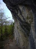
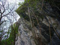
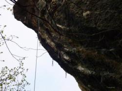
Rock :
limestone. Characteristic(s) : overhang  , steep wall
  , vertical
  . Type(s) of holds : underclings, pockets / holes, crimps.
We liked this/these route(s) : L'extremacura 8c+ ; The natural escape 8a+ ; Rêve de femme 7b+
Legendary route(s) :
Allertalos 8a ; Pablo 8b
L'extremacura Plus 8c/8c+ sent by Claudia Ghisolfi on 1 june 2021.
TCT 9a 4th 9a on sight in the world by Adam Ondra on 12 july 2014. Others outstandings sends : Claudia Ghisolfi (2022)
Allertalos 8a ; Pablo 8b
Web site(s) :
http://www.instrapiombo.com/gravere.htm
Locations :
Area :
Italy, Piemonte, Città Metropolitana di Torino, Torino, Susa.
|
|
Latitude : 45° 7' 23" N | Longitude : 7° 1' 29" E | Sexagesimal & Orientation |
|
|
Latitude : 45° 7' 21" N | Longitude : 7° 1' 22" E | Sexagesimal & Orientation |
| More coordinates |
Area added by Raffaela


