
")
")


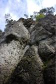
Frankenjura (Ruine Leienfels)
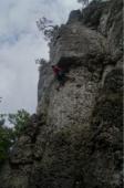
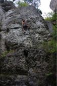
Interesting rock climbing area for routes from 6a to 6c and from 7a to 7c (french grades).
Best time(s) :
- January
- February
- March
- April
- May
- June
- July
- August
- Sept.
- Oct.
- Nov.
- Dec.
Aspect(s) : W-SW Altitude : 600 m
Approach 6 min easy up hill then easy down hill. Kids friendly ? foot of the crag reasonable for young kids.
Informations :
Between 10 and 25 routes, from 4- to 8. Bolting : traditionnal climbing, sport climbing
Max Height : 18 m.
Rock :
limestone. Characteristic(s) : overhang  , vertical
  . Type(s) of holds : pockets / holes, crimps, cracks.
Further information(s) : Partly new routes allowed, also parts are closed for climbing. However, nice and comfy climbs, very easy 7a.
Web site(s) :
http://www.frankenjura.com/klettern/poi/366
Locations :
Area :
Germany, Bayern, Regierungsbezirk Oberfranken, Pegnitz, Leienfels.
|
|
Latitude : 49° 42' 33" N | Longitude : 11° 22' 10" E | Sexagesimal & Orientation |
|
|
Latitude : 49° 42' 27" N | Longitude : 11° 22' 21" E | Sexagesimal & Orientation |
| More coordinates |
Area added by Sethai


