")
")


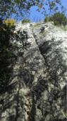
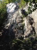
Frankenjura (Röthelfels)
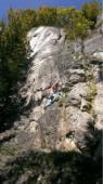
Interesting rock climbing area for routes up to 5c, from 6a to 6c and from 7a to 7c (french grades).
Best time(s) :
- January
- February
- March
- April
- May
- June
- July
- August
- Sept.
- Oct.
- Nov.
- Dec.
Aspect(s) : S-SE Altitude : 500 m
Approach 15 min
Informations :
More than 100 routes, from 3+ to 9+. Bolting : sport climbing
Max Height : 40 m.
Rock :
limestone. Characteristic(s) : steep wall  , vertical
  , slab
  . Type(s) of holds : pockets / holes.
Locations :
Area :
Germany, Bayern, Regierungsbezirk Oberfranken, Forchheim, Urspring.
|
|
Latitude : 49° 44' 52" N | Longitude : 11° 14' 37" E | Sexagesimal & Orientation |
|
|
Latitude : 49° 44' 39" N | Longitude : 11° 14' 53" E | Sexagesimal & Orientation |
| More coordinates |
Area added by CA