
")
")


Frankenjura (Herzogenreuther Wand)
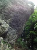
Interesting rock climbing area for routes from 6a to 6c, from 7a to 7c and starting from 8a (french grades).
Best time(s) :
- January
- February
- March
- April
- May
- June
- July
- August
- Sept.
- Oct.
- Nov.
- Dec.
Aspect(s) : W-S-SE Altitude : 500 m
Approach 2 min steep down hill. Kids friendly ? foot of the crag uneven for young kids.
Informations :
Between 10 and 25 routes, from 6 to 10+. Bolting : traditionnal climbing, sport climbing
Max Height : 15 m.
Rock :
chalk. Characteristic(s) : overhang  , steep wall
  . Type(s) of holds : pockets / holes, crimps, cracks, slopers.
We liked this/these route(s) : Earl Gray 10+
Very uneven ground, difficult to belay!
Web site(s) :
http://www.frankenjura.com/klettern/poi/277
Locations :
Area :
Germany, Bayern, Regierungsbezirk Oberfranken, Bamberg, Tiefenellern.
|
|
Latitude : 49° 54' 49" N | Longitude : 11° 5' 9" E | Sexagesimal & Orientation |
|
|
Latitude : 49° 54' 51" N | Longitude : 11° 5' 10" E | Sexagesimal & Orientation |
| More coordinates |
Area added by Sethai


