")
")


Franchi
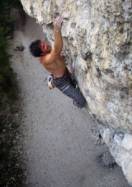
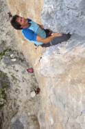
Interesting rock climbing area for routes from 7a to 7c (french grades).
Best time(s) :
- January
- February
- March
- April
- May
- June
- July
- August
- Sept.
- Oct.
- Nov.
- Dec.
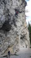
Aspect(s) : SE-E Altitude : 1400 m
Approach 3 min on flat ground. Kids friendly ? foot of the crag comfortable for young kids.
Informations :
Less than 10 routes, from 5a to 8b. Bolting : sport climbing
Max Height : 33 m.
Rock :
limestone (dolomie). Characteristic(s) : overhang  , steep wall
  . Type(s) of holds : side pulls, jugs, pockets / holes, crimps.
We liked this/these route(s) : Fr?lingserwachen, Minigolf
Further information(s) : You can climb here if it's raining.
Locations :
Area :
Italy, Trentino-Alto Adige, Provincia di Bolzano - Alto Adige, Brunico, Dobbiaco.
|
|
Latitude : 46° 38' 25" N | Longitude : 12° 13' 51" E | Sexagesimal & Orientation |
|
|
Latitude : 46° 38' 25" N | Longitude : 12° 13' 54" E | Sexagesimal & Orientation |
| More coordinates |
Area added by Enrico Maioni