
")
")


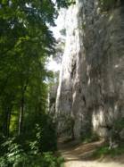
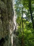
Falkenflue
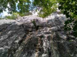
Interesting rock climbing area for routes up to 5c, from 6a to 6c, from 7a to 7c and starting from 8a (french grades).
Best time(s) :
- January
- February
- March
- April
- May
- June
- July
- August
- Sept.
- Oct.
- Nov.
- Dec.
Aspect(s) : W-SE Altitude : 600 m
Approach 15 min on flat ground. Kids friendly ? foot of the crag reasonable for young kids.
Informations :
More than 200 routes, from 3b to 8c , spread over 2 crags Bolting : sport climbing
Max Height : 50 m.
Rock :
limestone. Characteristic(s) : vertical  , steep wall
  . Type(s) of holds : cracks, pockets / holes, crimps.
Locations :
Area :
Switzerland, Solothurn, Bezirk Dorneck, Basel, Hochwald.
|
|
Latitude : 47° 27' 2" N | Longitude : 7° 37' 11" E | Sexagesimal & Orientation |
|
|
Latitude : 47° 27' 21" N | Longitude : 7° 37' 30" E | Sexagesimal & Orientation |
| More coordinates |
Area added by CA

