")
")


Estézargues beach
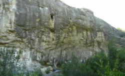

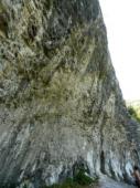
Interesting rock climbing area for routes from 7a to 7c and starting from 8a (french grades).
Best time(s) :
- January
- February
- March
- April
- May
- June
- July
- August
- Sept.
- Oct.
- Nov.
- Dec.
Aspect(s) : NW-N Altitude : 100 m
Approach 20 min down hill. Kids friendly ? foot of the crag reasonable for young kids.
Informations :
Between 10 and 25 routes, from 6c to 8c. Bolting : sport climbing
Max Height : 25 m.
Rock :
limestone. Characteristic(s) : steep wall  . Type(s) of holds : pockets / holes, crimps.
We liked this/these route(s) : Tailleur de pierre 6c+, Pack de bière 7b
Further information(s) : Voies courtes et bidouillées. La majorité des prises sont taillées ou collées au sika. Concernant la marche d'approche, du parking suivre la piste à pied vers l'Ouest. On arrive assez vite à une bifurcation, prendre la piste de gauche. 20m après un bon sentier descend à droite dans les gorges. Deux options : soit prendre ce sentier et une fois en bas, le poursuivre à gauche pendant 10/15 minutes. Le sentier passe quasiment au pied de la falaise. Soit continuer la piste pendant 10 minutes pour plonger ensuite à droite et rejoindre le fond du canyon par un sentier très mal indiqué. Une fois dans le canyon, on rejoint le bon sentier, la falaise se trouve 400m plus bas. L'intérêt principal de cette seconde option est de pouvoir venir avec une voiture "4x4" jusqu'au départ du sentier difficile à trouver, mais pour une première visite, il vaut mieux passer par le sentier du bas (qui est ombragé en plus) puis remonter par le mauvais sentier pour avoir une idée de son embranchement avec la piste.
Locations :
Area :
France, Occitanie, Gard (30), Avignon, Estézargues.
|
|
Latitude : 43° 57' 13" N | Longitude : 4° 36' 48" E | Sexagesimal & Orientation |
|
|
Latitude : 43° 57' 30" N | Longitude : 4° 37' 34" E | Sexagesimal & Orientation |
| More coordinates |
Area added by CA