")
")


Drnulk
Interesting rock climbing area for routes up to 5c, from 6a to 6c and from 7a to 7c (french grades).
Best time(s) :
- January
- February
- March
- April
- May
- June
- July
- August
- Sept.
- Oct.
- Nov.
- Dec.
Aspect(s) : SW Altitude : 650 m
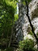
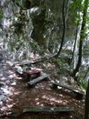
Approach 2 min easy up hill. Kids friendly ? foot of the crag comfortable for young kids.
Informations :
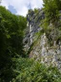
Between 50 and 100 routes, from 4a to 7b , spread over 4 crags Bolting : sport climbing
Max Height : 40 m.
Rock :
limestone. Characteristic(s) : dihedral  , overhang
  , steep wall
  , vertical
  , slab
  . Type(s) of holds : jugs, crimps, cracks.
Further information(s) : Grades writen at the foot of the routes.
Locations :
Area :
Slovenia, Goriška, Tolmin, Ljubljana, Dolenja Trebusa.
|
|
Latitude : 46° 3' 53" N | Longitude : 13° 48' 43" E | Sexagesimal & Orientation |
|
|
Latitude : 46° 3' 52" N | Longitude : 13° 48' 46" E | Sexagesimal & Orientation |
| More coordinates |
Area added by Gaseur