
")
")


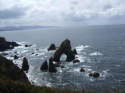
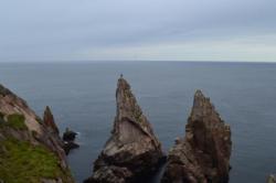
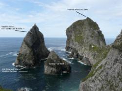
Donegal Sea Stacks
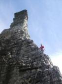
Interesting rock climbing area for routes up to 5c and from 6a to 6c (french grades).
Best time(s) :
- January
- February
- March
- April
- May
- June
- July
- August
- Sept.
- Oct.
- Nov.
- Dec.
Aspect(s) : All
Approach between 10 and 20 min by boat. Kids friendly ? foot of the crag dangerous for young kids.
Informations :
More than 100 routes, from S. 4a/b to E1 5b/c , spread over many crags Bolting : traditionnal climbing
Max Height : 220 m.
Rock :
quartzite. Characteristic(s) : slab  , vertical
  . Type(s) of holds : jugs, crimps, cracks, slopers.
Further information(s) : 45 crags !!
Web site(s) :
http://www.uniqueascent.ie/undiscovered_donegal http://iain-miller.blogspot.ie/2014/09/tormore-island-irelands-highest-seastack.html
Locations :
Area :
Ireland, Ulster, County Donegal, Donegal Town, Ardara.
|
|
Latitude : 54° 44' 50" N | Longitude : 8° 42' 13" W | Sexagesimal & Orientation |
| More coordinates |
Area added by Iain Miller

