
")
")


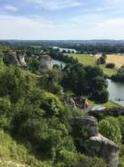
Connelles


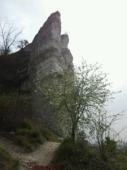
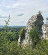
Interesting rock climbing area for routes up to 5c, from 6a to 6c and from 7a to 7c (french grades).
Best time(s) :
- January
- February
- March
- April
- May
- June
- July
- August
- Sept.
- Oct.
- Nov.
- Dec.
Aspect(s) : W Altitude : 50 m
Approach 5 min easy up hill. Kids friendly ? foot of the crag reasonable for young kids.
Informations :
More than 300 routes, from 3c to 7c. Bolting : big run out climbing
Max Height : 35 m.
Rock :
chalk. Characteristic(s) : steep wall  , vertical
  , slab
  . Type(s) of holds : pockets / holes, crimps, slopers.
Un utilisateur a rapporté :"Suite à un éboulement en avril 2013, les secteurs 4 et 5 sont interdit d'accès jusqu'à nouvel ordre.".
Locations :
Area :
France, Normandie, Eure (27), Rouen, Connelles.
|
|
Latitude : 49° 16' 35" N | Longitude : 1° 16' 18" E | Sexagesimal & Orientation |
|
|
Latitude : 49° 16' 36" N | Longitude : 1° 16' 16" E | Sexagesimal & Orientation |
| More coordinates |
Area added by CA


