")
")


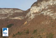
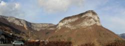
Col de la Doriaz
Interesting rock climbing area for routes from 6a to 6c and from 7a to 7c (french grades).
Best time(s) :
- January
- February
- March
- April
- May
- June
- July
- August
- Sept.
- Oct.
- Nov.
- Dec.
Aspect(s) : SW-S Altitude : 1100 m
Approach 15 min up hill then down hill. Kids friendly ? foot of the crag reasonable for young kids.
Informations :
Between 10 and 25 routes, from 5c to 8a. Bolting : sport climbing
Max Height : 25 m. Average Height : 20 m.
Rock :
limestone. Characteristic(s) : vertical  . Type(s) of holds : crimps.
Further information(s) : The "Col de la Doria" as the local call it is a beautiful cliff with an easy 15 min approach. You climb here on a compact limestone and the routes can be technical where using feet is crucial! The view is always pleasant from the routes, while the foot of the crag is in the shade of trees. That's very appreciated when the sun hits hard!
Furthermore one can combine a half-day climbing with a visit to the beautiful waterfall called Doria as well, or by going to stretch your arms on one of the via ferrata. Waterfall and via ferrata are located only fifteen minutes hiking from the crag.
Accès: Depuis Chambéry prendre la direction du Massif des Bauges, 2ème sortie à droite après le tunnel des Monts, monter à St Jean d’Arvey par la D912, continuer sur cette route jusqu’à un embranchement (juste après le lieu dit « La Combe ») où est indiqué le « Parking Via Ferrata » (D206a).
Au lieu dit « La Ville » prendre à gauche puis suivre encore le « Parking Via Ferrata » et s’y garer.
Suivre les panneaux indiquant le « rocher d’escalade ».
Attention bien faire le tour par la droite de la première ferme rencontrée.
Watch out: Birds can nest on « benoites » route.
Locations :
Area :
France, Auvergne-Rhône-Alpes, Savoie (73), Chambéry, Les déserts.
|
|
Latitude : 45° 36' 23" N | Longitude : 5° 59' 6" E | Sexagesimal & Orientation |
|
|
Latitude : 45° 36' 41" N | Longitude : 5° 59' 35" E | Sexagesimal & Orientation |
| More coordinates |
Area added by Topnanou