Chemin du Roy
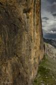
Interesting rock climbing area for routes from 7a to 7c (french grades).
![Information](/images/attention.png)
Many additional skills about progressing, belaying, escaping technics ... are necessary for multipitch routes security.
Best time(s) : - January
- February
- March
- April
- May
- June
- July
- August
- Sept.
- Oct.
- Nov.
- Dec.
Aspect(s) : S Altitude : 2000 m
Approach 30 min steep up hill. Kids friendly ? foot of the crag dangerous for young kids.
Informations :
Between 10 and 25 routes, from 5a to 6a. Bolting : traditionnal climbing, sport climbing
Max Height : 200 m.
Rock :
limestone.
Characteristic(s) : slab
![Dalle](/images/dalle.png)
, vertical
![Vertical](/images/vertical.png)
.
Type(s) of holds : crimps, cracks.
Locations :
Area :
France, Provence-Alpes-Côte d'Azur, Hautes-Alpes (05), Briançon, Le Lauzet.
![Information](/images/readme.png)
1. Zoom in to get all the rock climbing places 200 km around.
![](/images/mm_20_green.png)
: Bouldering
![](/images/mm_20_orange.png)
: Single pitch
![](/images/mm_20_red.png)
: Multi pitches
![](/images/mm_20_blue.png)
: Deep water soloing
![](/images/mm_20_white.png)
: Differents kind of climbing
Rock climbing area GPS Coordinates : |
Latitude : 45° 1' 35" N |
Longitude : 6° 27' 30" E |
Sexagesimal & Orientation
|
|
Latitude : 45° 1' 35" |
Longitude : 6° 27' 30" |
Degrees, Minutes, Seconds (DMS)
|
|
Latitude : 45° 1.593' |
Longitude : 6° 27.511' |
Degrees, Décimal minutes (DM)
|
|
Latitude : 45.026549° |
Longitude : 6.458518° |
Decimal degrees (DD)
|
|
Parking lot GPS Coordinates : |
Latitude : 45° 1' 23" N |
Longitude : 6° 27' 22" E |
Sexagesimal & Orientation
|
|
Latitude : 45° 1' 23" |
Longitude : 6° 27' 22" |
Degrees, Minutes, Seconds (DMS)
|
|
Latitude : 45° 1.386' |
Longitude : 6° 27.376' |
Degrees, Décimal minutes (DM)
|
|
Latitude : 45.023102° |
Longitude : 6.45626° |
Decimal degrees (DD)
|
Area added by someone who did not leave her/his name :)