")
")


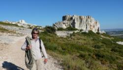
Chateau-Virant, Calissanne
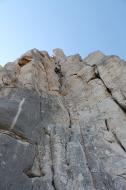

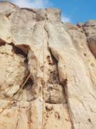

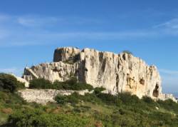


Interesting rock climbing area for routes up to 5c and from 6a to 6c (french grades).
Best time(s) :
- January
- February
- March
- April
- May
- June
- July
- August
- Sept.
- Oct.
- Nov.
- Dec.
Aspect(s) : All Altitude : 100 m
Approach 5 min on flat ground. Kids friendly ? foot of the crag reasonable for young kids.
Informations :
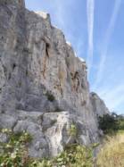
Between 50 and 100 routes, from 3b to 7a. Bolting : sport climbing
Max Height : 20 m.
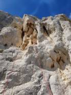
Rock :
limestone. Characteristic(s) : slab  , vertical
  , dihedral
  . Type(s) of holds : pockets / holes, crimps, cracks.
Par rapport aux risques d'incendies dans les Bouches du Rhône : du 1er juin au 30 septembre, réglementation par arrêté préfectoral mis à jour au mois de mai de chaque année.
Carte des risques par massifs à consulter sur le site : http://www.bouches-du-rhone.pref.gouv.fr/massifs/index.php
Ou sur le serveur vocal : 08.11.20.13.13
Carte des risques par massifs à consulter sur le site : http://www.bouches-du-rhone.pref.gouv.fr/massifs/index.php
Ou sur le serveur vocal : 08.11.20.13.13
Locations :
Area :
France, Provence-Alpes-Côte d'Azur, Bouches-du-Rhône (13), Aix-en-Provence, La Fare-les-Oliviers.
|
|
Latitude : 43° 33' 16" N | Longitude : 5° 8' 31" E | Sexagesimal & Orientation |
|
|
Latitude : 43° 33' 25" N | Longitude : 5° 8' 28" E | Sexagesimal & Orientation |
| More coordinates |
Area added by pf.b