
")
")


Cerro Cabrillo (Rocl Land & El Dorado)
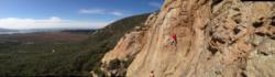


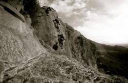
Interesting rock climbing area for routes up to 5c and from 6a to 6c (french grades).
Best time(s) :
- January
- February
- March
- April
- May
- June
- July
- August
- Sept.
- Oct.
- Nov.
- Dec.
Aspect(s) : S Altitude : 100 m
Approach 10 min easy up hill. Kids friendly ? foot of the crag comfortable for young kids.
Informations :
Between 25 and 50 routes, from 5.6 to 5.11a , spread over many crags Bolting : sport climbing
Rock :
granite. Characteristic(s) : slab  , vertical
  . Type(s) of holds : crimps, cracks, slopers.
Locations :
Area :
United States, California, San Luis Obispo County, San Luis Obispo, Morro Bay.
|
|
Latitude : 35° 20' 56" N | Longitude : 120° 49' 18" W | Sexagesimal & Orientation |
|
|
Latitude : 35° 20' 47" N | Longitude : 120° 49' 29" W | Sexagesimal & Orientation |
| More coordinates |
Area added by someone who did not leave her/his name :)

