
")
")


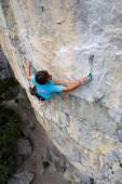
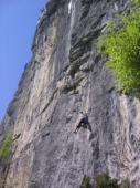
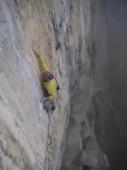
Cascade de Doran
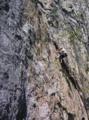
Interesting rock climbing area for routes from 6a to 6c and from 7a to 7c (french grades).
Best time(s) :
- January
- February
- March
- April
- May
- June
- July
- August
- Sept.
- Oct.
- Nov.
- Dec.
Aspect(s) : E Altitude : 1300 m
Approach 15 min up hill. Kids friendly ? foot of the crag dangerous for young kids.
Informations :
Between 25 and 50 routes, from 5b to 8b. Bolting : sport climbing
Max Height : 45 m.
Rock :
limestone. Characteristic(s) : slab  , vertical
  . Type(s) of holds : crimps, cracks.
Further information(s) : A high, vertical, grey and orange limestone wall (about 70m), in a very quiet place with view of the mountains. The long routes are generally the more interesting but you'll need a level of 7a+ up to 8b. Many routes are sheltered from the rain, some dry pretty slowly but others never get wet. In summer, it's difficult to climb in the morning because of the heat, but it becomes pleasant after 13h when the crag is in the shade, thanks to the breeze which blows on sunny days.
Locations :
Area :
France, Auvergne-Rhône-Alpes, Haute-Savoie (74), Cluses, Sallanches.
|
|
Latitude : 45° 58' 11" N | Longitude : 6° 35' 47" E | Sexagesimal & Orientation |
|
|
Latitude : 45° 57' 45" N | Longitude : 6° 36' 1" E | Sexagesimal & Orientation |
| More coordinates |
Area added by CA


