
")
")


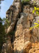
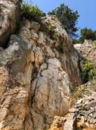
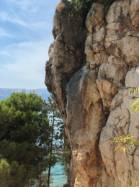
Bunculuka
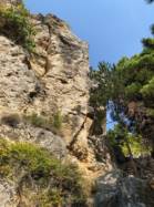

Interesting rock climbing area for routes up to 5c and from 6a to 6c (french grades).
Best time(s) :
- January
- February
- March
- April
- May
- June
- July
- August
- Sept.
- Oct.
- Nov.
- Dec.
Aspect(s) : SE Altitude : 50 m
Approach 20 min easy up hill then easy down hill. Kids friendly ? foot of the crag reasonable for young kids.
Informations :
Between 10 and 25 routes, from 5a to 7b. Bolting : traditionnal climbing, sport climbing
Max Height : 16 m.
Rock :
limestone. Characteristic(s) : steep wall  , vertical
  , slab
  . Type(s) of holds : pockets / holes, crimps, water erosion pockets, pebbles, cracks.
You have to walk around the camping area! The direct way over the beach is not allowed. It belongs to the camping. Or you pay 30kn to walk through.
Web site(s) :
http://www.turm-krk.de/uploads/images/LR7NuqtankIvr5f0b0eo3w/climbing_baska_bunculuka_topo.pdf
Locations :
Area :
Croatia, Primorsko-goranska županija, Općina Baška, Krk, Baška.
|
|
Latitude : 44° 58' 8" N | Longitude : 14° 46' 28" E | Sexagesimal & Orientation |
|
|
Latitude : 44° 58' 0" N | Longitude : 14° 46' 7" E | Sexagesimal & Orientation |
| More coordinates |
Area added by Shinkey


