")
")


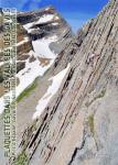
 Bois de Lourdes
Rock climbing at Bois de Lourdes is strictly forbidden

Interesting rock climbing area for routes from 7a to 7c and starting from 8a (french grades).
Best time(s) :
- January
- February
- March
- April
- May
- June
- July
- August
- Sept.
- Oct.
- Nov.
- Dec.
Aspect(s) : E-NE Altitude : 450 m
Approach 1 min up hill
Informations :
Between 25 and 50 routes, from 6a to 8c , spread over 4 crags Bolting : sport climbing
Max Height : 20 m.
Rock :
limestone. Characteristic(s) : slab  , vertical
  , steep wall
  , overhang
  . Type(s) of holds : crimps, slopers.
We liked this/these route(s) : L’huile d’olive 8a
Further information(s) : Training routes. A lot of people on some routes.
Site interdit à l'escalade par arrêtée municipal.
Web site(s) :
http://igaby.ifrance.com/index1.htm
Locations :
Area :
France, Occitanie, Hautes-Pyrénées (65), Tarbes, Lourdes.
|
|
Latitude : 43° 5' 36" N | Longitude : 0° 4' 35" W | Sexagesimal & Orientation |
|
|
Latitude : 43° 5' 35" N | Longitude : 0° 4' 34" W | Sexagesimal & Orientation |
| More coordinates |
Area added by Cannac Mélanie