
")
")


Bisotun
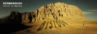
Interesting rock climbing area for routes from 6a to 6c and from 7a to 7c (french grades).
Best time(s) :
- January
- February
- March
- April
- May
- June
- July
- August
- Sept.
- Oct.
- Nov.
- Dec.
Aspect(s) : All Altitude : 1500 m
Approach up hill. Kids friendly ? foot of the crag uneven for young kids.
Informations :
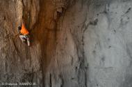
Between 25 and 50 routes, from 5c to 7b , spread over many crags Bolting : traditionnal climbing, sport climbing
Max Height : 1200 m.
Rock :
limestone. Characteristic(s) : slab  , vertical
  , steep wall
  . Type(s) of holds : crimps, cracks.
Further information(s) : Place of an international festival of rock climbing.
Guidebook at the Mister Sherzadi restaurant.
Guidebook at the Mister Sherzadi restaurant.
Locations :
Area :
Iran, Kermanshah Province (استان کرمانشاه), Harsin county (شهرستان هرسین), Kermanshah, Bisotun.
|
|
Latitude : 34° 22' 54" N | Longitude : 47° 25' 16" E | Sexagesimal & Orientation |
| More coordinates |
VIDEOS
Area added by CA

