")
")


Biclop & Talabar
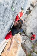
Interesting rock climbing area for routes from 6a to 6c and from 7a to 7c (french grades).
Best time(s) :
- January
- February
- March
- April
- May
- June
- July
- August
- Sept.
- Oct.
- Nov.
- Dec.
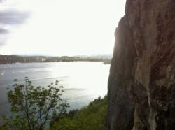
Aspect(s) : SW Altitude : 500 m
Approach 5 min up hill. Kids friendly ? foot of the crag uneven for young kids.
Informations :
More than 100 routes, from 4c to 8b. Bolting : sport climbing
Max Height : 120 m.
Rock :
limestone. Characteristic(s) : vertical  . Type(s) of holds : crimps, water erosion pockets.
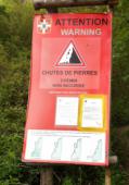
Falaise interdite pour travaux de sécurité jusqu'à nouvel ordre.
Négociations en cours entre le CAF et la mairie de Veyrier (mai 2017).
Négociations en cours entre le CAF et la mairie de Veyrier (mai 2017).
Locations :
Area :
France, Auvergne-Rhône-Alpes, Haute-Savoie (74), Annecy, Chavoire.
|
|
Latitude : 45° 53' 57" N | Longitude : 6° 9' 47" E | Sexagesimal & Orientation |
|
|
Latitude : 45° 53' 53" N | Longitude : 6° 9' 46" E | Sexagesimal & Orientation |
| More coordinates |
Area added by CA