
")
")


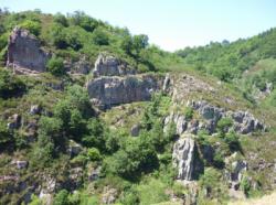
Bez Bédène
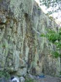

Interesting rock climbing area for routes up to 5c, from 6a to 6c and from 7a to 7c (french grades).
Best time(s) :
- January
- February
- March
- April
- May
- June
- July
- August
- Sept.
- Oct.
- Nov.
- Dec.
Aspect(s) : SE Altitude : 500 m
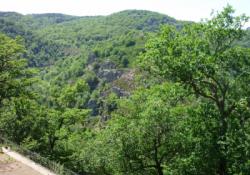
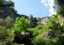
Approach 30 min steep down hill then steep up hill. Kids friendly ? foot of the crag reasonable for young kids.
Informations :
Between 25 and 50 routes, from 3b to 7b , spread over many crags Bolting : sport climbing
Max Height : 25 m.
Rock :
granite. Characteristic(s) : dihedral  , vertical
  , slab
  . Type(s) of holds : side pulls, jugs, pockets / holes, crimps, cracks.
Further information(s) : Superbe site tant au niveau de la grimpe que pour son environnement ainsi que le chemin accès.
Le topo du site est disponible à l'office de tourisme de Sainte-Geneviève-sur-Argence ou alors vous pouvez gentiment le demander à la tenancière du bar du parking de Bez Bédène et en prendre une photo. Le mieux c'est de laisser au bar car les exemplaires se font de plus en plus rares, alors pensez aux autre grimpeurs qui viendront après vous. Pour la marche d'approche, descendez 150 m après le parking et emprunter le chemin qui passe sous le vieux four du village. Suivez le sentier, traverser la rivière et dans la montée suivez le sentier balisé en bleu qui part vers la gauche.
Le topo du site est disponible à l'office de tourisme de Sainte-Geneviève-sur-Argence ou alors vous pouvez gentiment le demander à la tenancière du bar du parking de Bez Bédène et en prendre une photo. Le mieux c'est de laisser au bar car les exemplaires se font de plus en plus rares, alors pensez aux autre grimpeurs qui viendront après vous. Pour la marche d'approche, descendez 150 m après le parking et emprunter le chemin qui passe sous le vieux four du village. Suivez le sentier, traverser la rivière et dans la montée suivez le sentier balisé en bleu qui part vers la gauche.
No fire !
Locations :
Area :
France, Occitanie, Aveyron (12), Entraygues-sur-Truyère, Saint-Amans-des-Cots.
|
|
Latitude : 44° 39' 56" N | Longitude : 2° 38' 34" E | Sexagesimal & Orientation |
|
|
Latitude : 44° 39' 59" N | Longitude : 2° 38' 45" E | Sexagesimal & Orientation |
| More coordinates |
Area added by Lemouzy François

