
")
")


 Béruges 1
Rock climbing at Béruges 1 is strictly forbidden

Interesting rock climbing area for routes up to 5c, from 6a to 6c and from 7a to 7c (french grades).
Best time(s) :
- January
- February
- March
- April
- May
- June
- July
- August
- Sept.
- Oct.
- Nov.
- Dec.
Aspect(s) : SW-S Altitude : 100 m
Approach 2 min up hill. Kids friendly ? foot of the crag comfortable for young kids.
Informations :
Between 50 and 100 routes, from 4c to 7c , spread over 2 crags Bolting : sport climbing
Max Height : 20 m.
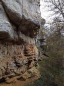
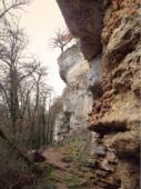
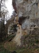
Rock :
limestone. Characteristic(s) : steep wall  , vertical
  , slab
  . Type(s) of holds : pockets / holes, crimps.
We liked this/these route(s) : Charlie cartonne 7c ; Noce de sang 7a (facile)
Further information(s) : Rock pretty fatty in the area of steep walls when it is hot.
Le propriétaire interdit l'accès.
Un bloc rocheux à gauche du secteur des dévers était interdit d'accès (des clous avaient été retirés).
Un bloc rocheux à gauche du secteur des dévers était interdit d'accès (des clous avaient été retirés).
Locations :
Area :
France, Nouvelle-Aquitaine, Vienne (86), Poitiers, Béruges.
|
|
Latitude : 46° 34' 15" N | Longitude : 0° 13' 17" E | Sexagesimal & Orientation |
|
|
Latitude : 46° 34' 17" N | Longitude : 0° 13' 8" E | Sexagesimal & Orientation |
| More coordinates |
Area added by DECRA Frédéric

