
")
")


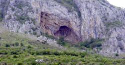
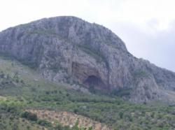
Archidona
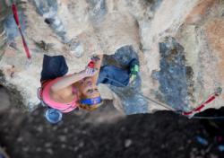

Interesting rock climbing area for routes from 6a to 6c, from 7a to 7c and starting from 8a (french grades).
Best time(s) :
- January
- February
- March
- April
- May
- June
- July
- August
- Sept.
- Oct.
- Nov.
- Dec.
Aspect(s) : W-SW-S Altitude : 850 m
Approach between 10 and 15 min up hill. Kids friendly ? foot of the crag reasonable for young kids.
Informations :
More than 100 routes, from 4b to 9a , spread over many crags Bolting : sport climbing
Max Height : 50 m.
Rock :
limestone. Characteristic(s) : overhang  , steep wall
  , vertical
  , slab
  . Type(s) of holds : crimps, ribs.
Legendary route(s) :
Kalliste 8c sent by Aleksandra Taistra on 28 april 2012.
El duende 9a first ascent by Bernabé Fernandez on 2009.
Orujo 9a+ 3rd 9a+ in the world by Bernabé Fernandez on 1998
Locations :
Area :
Spain, Andalucía, Provincia de Málaga, Antequera, Archidona.
|
|
Latitude : 37° 6' 24" N | Longitude : 4° 23' 18" W | Sexagesimal & Orientation |
|
|
Latitude : 37° 6' 28" N | Longitude : 4° 23' 25" W | Sexagesimal & Orientation |
| More coordinates |
VIDEOS
Area added by CA


