")
")

Grimper autour de Dijon (Bourgogne-Franche-Comté)
Saffres
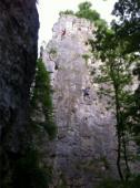
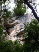
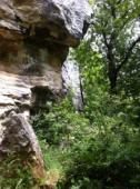
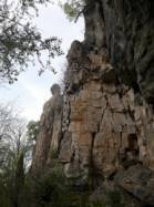
Site de voies d'une longueur intéressant pour ses voies jusqu'au 5c, du 6a au 6c et du 7a au 7c .
Meilleure(s) période(s) :
- Janvier
- Février
- Mars
- Avril
- Mai
- Juin
- Juillet
- Août
- Sept.
- Oct.
- Nov.
- Déc.
Orientation(s) : SW-S Altitude au pied des voies : 500 m
Marche d'approche : 10 min sur du plat. Environnement du site : pied des voies correct pour les jeunes enfants.
Description de l'escalade :
Plus de 400 voies, du 3b au 8a. Equipement : sportif
Hauteur max : 35 m.
Rocher :
calcaire. Profil(s) : vertical  , dalle
  . Type(s) de prises : réglettes.
Voie(s) Mythique(s) :
Le Râteau 6c (1er 6c français Jean-Claude Droyer 1977) ; Boulevard à Mathieux 7b (3ème 7b français Benoît Grison 1980)
Le Râteau 6c 5ème 6c au monde par Jean-Claude Droyer en 1977
Le Râteau 6c (1er 6c français Jean-Claude Droyer 1977) ; Boulevard à Mathieux 7b (3ème 7b français Benoît Grison 1980)
Localisations :
Lieu :
France, Bourgogne-Franche-Comté, Côte-d'Or (21), Dijon, Viteaux.
|
|
Latitude : 47° 22' 19" N | Longitude : 4° 34' 52" E | Sexagésimales & Orientation |
|
|
Latitude : 47° 22' 13" N | Longitude : 4° 35' 1" E | Sexagésimales & Orientation |
| Plus de coordonnées |
Site ajouté par CA