")
")


Malsaire

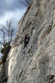
Interesting rock climbing area for routes up to 5c, from 6a to 6c and from 7a to 7c (french grades).
Best time(s) :
- January
- February
- March
- April
- May
- June
- July
- August
- Sept.
- Oct.
- Nov.
- Dec.
Aspect(s) : SW-S Altitude : 950 m
Approach 5 min down hill then up hill. Kids friendly ? foot of the crag reasonable for young kids.
Informations :
Between 50 and 100 routes, from 3b to 8b. Bolting : sport climbing
Max Height : 30 m.
Rock :
limestone. Characteristic(s) : steep wall  , vertical
  , slab
  . Type(s) of holds : crimps.
Further information(s) : Le site est assez ombragé par les arbres, mais chaud dès que les feuilles sont tombées et que le soleil brille : On peut y grimper l’hiver quand les conditions météo sont favorables : fin décembre, soleil de 10 h 30/11 h jusqu’en milieu d’après-midi. Le dévers sèche lentement (Résurgences assez tenaces après de fortes pluies). Il n’y a pas de danger à amener des enfants mais le pied de la falaise n’est pas très confortable : ni très plat, ni très large.
Equipement : Broches scellées, goujons de 10 et 12 mm, chevilles de 10 mm et peut-être encore quelques une en 8 mm
Approach: From the Pincru area of Mont-Saxonnex, follow the road towards Bonneville. 250m after the chapel take the road towards Malsaire. Park on the left just after the end of the tarmac road. Please respect the private properties. On foot, take the track which goes down to the last house, then enter the woods and follow a path which quickly leads to the crag.
Please respect the private properties.
Locations :
Area :
France, Auvergne-Rhône-Alpes, Haute-Savoie (74), Annemasse, Mont-Saxonnex.
|
|
Latitude : 46° 3' 7" N | Longitude : 6° 27' 45" E | Sexagesimal & Orientation |
|
|
Latitude : 46° 3' 2" N | Longitude : 6° 28' 3" E | Sexagesimal & Orientation |
| More coordinates |
Area added by someone who did not leave her/his name :)