
")
")


Les Dentelles de Montmirail (Rocher Saint-Christophe)
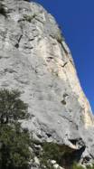
Interesting rock climbing area for routes from 6a to 6c (french grades).
Best time(s) :
- January
- February
- March
- April
- May
- June
- July
- August
- Sept.
- Oct.
- Nov.
- Dec.
Aspect(s) : W-S-N Altitude : 300 m
Approach between 2 and 5 min up hill. Kids friendly ? foot of the crag uneven for young kids.
Informations :
Between 25 and 50 routes, from 3b to 7b , spread over many crags Bolting : sport climbing
Max Height : 40 m.
Rock :
limestone. Characteristic(s) : vertical  . Type(s) of holds : crimps.
Locations :
Area :
France, Provence-Alpes-Côte d'Azur, Vaucluse (84), Avignon, Lafare.
|
|
Latitude : 44° 9' 26" N | Longitude : 5° 2' 51" E | Sexagesimal & Orientation |
|
|
Latitude : 44° 9' 23" N | Longitude : 5° 2' 49" E | Sexagesimal & Orientation |
| More coordinates |
Area added by Olivier marquet


