
")
")


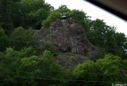
Grafensprung
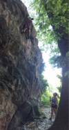
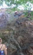
Interesting rock climbing area for routes up to 5c and from 6a to 6c (french grades).
Best time(s) :
- January
- February
- March
- April
- May
- June
- July
- August
- Sept.
- Oct.
- Nov.
- Dec.
Aspect(s) : SE-E Altitude : 200 m
Approach 5 min easy up hill. Kids friendly ? foot of the crag dangerous for young kids.
Informations :
Less than 10 routes, from 3 to 7. Bolting : sport climbing
Max Height : 20 m.
Rock :
porphyre. Characteristic(s) : steep wall  , vertical
  , slab
  . Type(s) of holds : underclings, jugs, crimps, cracks.
Further information(s) : L'accès aux voies se fait par le côté droit de l'abri, le long du rocher.
Web site(s) :
http://felsinfo.alpenverein.de/index.php?mapId=82&option=com_content&view=article&id=840&fels=1311 http://scale=18055¢erX=929170¢erY=6232340&layers=1465218397,152917,0
Locations :
Area :
Germany, Baden-Württemberg, Landkreis Karlsruhe, Baden-Baden, Gernsbach.
|
|
Latitude : 48° 44' 54" N | Longitude : 8° 20' 49" E | Sexagesimal & Orientation |
|
|
Latitude : 48° 44' 46" N | Longitude : 8° 20' 44" E | Sexagesimal & Orientation |
| More coordinates |
Area added by quelqu'un qui n'a pas laissé son nom :)

