")
")

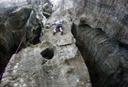
Les grottes de Koumac
Escuela interesante para sus vías hasta el 5c .
Orientación(es) : SW Altitud : 50 m
Approximación :2 min llano. Entorno : pie de las vías correcto para los niños.
Informaciones :
Entre 10 y 25 vías, de 4b hasta 6b. Equipamiento : deportiva
Roca :
silex, caliza. Perfil(es) : vertical  . Tipos de agarres : regletas.
Más informacione(s) : Family area with 2 different sectors.
Attention in case of heavy rain the track may be impassable at the raft.
A picnic table in the shade of large trees, allows enjoying the charm of this site.
You will find a water point at the entrance.
Both sectors are located on each side of one of the caves of the site. The limestone rock with small flints will offer a rock climbing whith flexibility and precision.
Sitio(s) web :
http://vertikaledonie.com/2012/07/les-grottes-de-koumac/
Ubicaciónes :
Lugar :
Francia, DROM-COM, Nouvelle-Calédonie (988), Province Nord, Koumac.
|
|
Latitud : 20° 32' 5" S | Longitud : 164° 20' 24" E | Sexagésimales y Orientación |
|
|
Latitud : 20° 32' 8" S | Longitud : 164° 20' 23" E | Sexagésimales y Orientación |
| Más coordenadas |
Escuela añadida por CA