
")
")

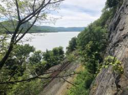
Grimper autour de Newburgh (State of New York)
West Point

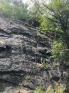
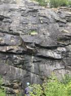

Site de voies d'une longueur intéressant pour ses voies jusqu'au 5c et du 6a au 6c .
Meilleure(s) période(s) :
- Janvier
- Février
- Mars
- Avril
- Mai
- Juin
- Juillet
- Août
- Sept.
- Oct.
- Nov.
- Déc.
Orientation(s) : E Altitude au pied des voies : 7 m
Marche d'approche : 10 min sur du plat. Environnement du site : pied des voies confortable pour les jeunes enfants.
Description de l'escalade :
Entre 50 et 100 voies, du 5.1 au 5.12d. Equipement : sportif
Hauteur max : 20 m.
Rocher :
schiste. Profil(s) : dalle  , vertical
  . Type(s) de prises : verticales, inversées, grosses prises, réglettes, àplats.
Information(s) supplémentaire(s) : Parking is $5 for the day at the bottom of Station Hill Rd. The approach is walking about 0.25 miles north along the train tracks. The crag is just past the waterfall. The wall has many obvious bolts on it -- you will know when you have arrived.
This entry is specific to the Poison Ivy Wall.
This entry is specific to the Poison Ivy Wall.
The train tracks are active. Keep your gear as close to the crag as possible!
When trains come through it is nearly impossible for a climber to communicate with his/her belayer.
Lead falls on such slabby, ledgy routes can hurt!
Camping is not allowed.
There are lots of ants at the base, so watch your lunch!
When trains come through it is nearly impossible for a climber to communicate with his/her belayer.
Lead falls on such slabby, ledgy routes can hurt!
Camping is not allowed.
There are lots of ants at the base, so watch your lunch!
Site(s) internet :
http://www.rockclimbing.com/routes/North_America/United_States/New_York/Upstate/Poison_Ivy_Wall/ http://www.mountainproject.com/v/west-point/107323592
Localisations :
Lieu :
United States, State of New York, Orange County, Newburgh, West Point.
|
|
Latitude : 41° 22' 50" N | Longitude : 73° 57' 29" W | Sexagésimales & Orientation |
|
|
Latitude : 41° 22' 29" N | Longitude : 73° 57' 38" W | Sexagésimales & Orientation |
| Plus de coordonnées |
Site ajouté par Jake Starr

