
")
")


Saint Léonard
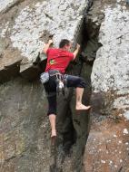

Interesting rock climbing area for routes up to 5c, from 6a to 6c and from 7a to 7c (french grades).
Best time(s) :
- January
- February
- March
- April
- May
- June
- July
- August
- Sept.
- Oct.
- Nov.
- Dec.
Aspect(s) : N Altitude : 150 m
Approach 1 min on flat ground
Informations :
Between 10 and 25 routes, from 4c to 7a. Bolting : sport climbing
Max Height : 17 m.
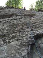
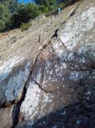
Rock :
limestone. Characteristic(s) : vertical  , slab
  . Type(s) of holds : jugs, crimps.
Further information(s) : Très belles voies dans le 6 et le 7.
Locations :
Area :
France, Pays de la Loire, Sarthe (72), Alençon, Saint-Léonard-des-Bois.
|
|
Latitude : 48° 21' 11" N | Longitude : 0° 4' 50" W | Sexagesimal & Orientation |
|
|
Latitude : 48° 21' 10" N | Longitude : 0° 4' 51" W | Sexagesimal & Orientation |
| More coordinates |
Area added by Malo Nicolle

