
")
")


Quès
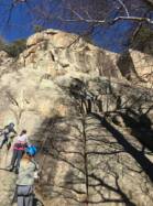
Interesting rock climbing area for routes up to 5c and from 6a to 6c (french grades).
Best time(s) :
- January
- February
- March
- April
- May
- June
- July
- August
- Sept.
- Oct.
- Nov.
- Dec.
Aspect(s) : SE Altitude : 1350 m
Approach 1 min up hill. Kids friendly ? foot of the crag comfortable for young kids.
Informations :
Between 10 and 25 routes, from 3a to 6b , spread over many crags Bolting : sport climbing
Max Height : 30 m. Average Height : 15 m.
Rock :
granite. Characteristic(s) : vertical  , slab
  . Type(s) of holds : crimps.
Locations :
Area :
France, Occitanie, Pyrénées-Orientales (66), Puigcerdà, Latour-de-Carol.
|
|
Latitude : 42° 29' 5" N | Longitude : 1° 51' 39" E | Sexagesimal & Orientation |
|
|
Latitude : 42° 29' 2" N | Longitude : 1° 51' 38" E | Sexagesimal & Orientation |
| More coordinates |
Area added by quelqu'un qui n'a pas laissé son nom :)

