
")
")


Le Manchet
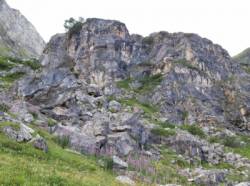
Interesting rock climbing area for routes up to 5c, from 6a to 6c and from 7a to 7c (french grades).
Best time(s) :
- January
- February
- March
- April
- May
- June
- July
- August
- Sept.
- Oct.
- Nov.
- Dec.
Aspect(s) : E Altitude : 2050 m
Approach steep down hill then steep up hill
Informations :
Between 25 and 50 routes, from 3a to 8a. Bolting : sport climbing
Max Height : 30 m. Average Height : 20 m.
Rock :
gneiss. Characteristic(s) : vertical  . Type(s) of holds : crimps.
Locations :
Area :
France, Auvergne-Rhône-Alpes, Savoie (73), Bourg-Saint-Maurice, Val d'Isère.
|
|
Latitude : 45° 24' 58" N | Longitude : 6° 58' 12" E | Sexagesimal & Orientation |
|
|
Latitude : 45° 25' 2" N | Longitude : 6° 58' 11" E | Sexagesimal & Orientation |
| More coordinates |
Area added by Benoit71l57

