
")
")


Baga de la Guillota (Sot del Torn)
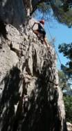
Interesting rock climbing area for routes up to 5c and from 6a to 6c (french grades).
Best time(s) :
- January
- February
- March
- April
- May
- June
- July
- August
- Sept.
- Oct.
- Nov.
- Dec.
Aspect(s) : SE-E-N Altitude : 500 m
Approach 5 min easy down hill then easy up hill. Kids friendly ? foot of the crag reasonable for young kids.
Informations :
Between 25 and 50 routes, from 4a to 6c , spread over many crags Bolting : sport climbing
Max Height : 15 m.
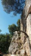
Rock :
limestone (dolomie). Characteristic(s) : vertical  , dihedral
  . Type(s) of holds : tafonis, side pulls, underclings, jugs, pockets / holes, crimps, water erosion pockets, cracks, tufas.
Locations :
Area :
Spain, Cataluña (Catalunya), Provincia de Barcelona, Granollers, Tagamanent.
|
|
Latitude : 41° 44' 8" N | Longitude : 2° 15' 23" E | Sexagesimal & Orientation |
|
|
Latitude : 41° 44' 13" N | Longitude : 2° 15' 24" E | Sexagesimal & Orientation |
| More coordinates |
Area added by Wall Worker

