
")
")


Alto del Telégrafo


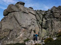
Interesting rock climbing area for routes from 6a to 6c and from 7a to 7c (french grades).
Best time(s) :
- January
- February
- March
- April
- May
- June
- July
- August
- Sept.
- Oct.
- Nov.
- Dec.
Aspect(s) : All Altitude : 1950 m
Approach 30 min easy up hill then easy down hill. Kids friendly ? foot of the crag dangerous for young kids.
Informations :
Between 25 and 50 routes, from 5a to 8a. Bolting : sport climbing
Max Height : 35 m.
Rock :
granite. Characteristic(s) : slab  , steep wall
  , dihedral
  . Type(s) of holds : crimps, cracks.
Web site(s) :
http://www.enlavertical.com/escuelas/view/300 http://skyrun.blogspot.com.es/2007/09/alto-del-telgrafo.html
Locations :
Area :
Spain, Comunidad de Madrid, Sierra Norte, Madrid, Navacerrada.
|
|
Latitude : 40° 46' 55" N | Longitude : 4° 0' 57" W | Sexagesimal & Orientation |
|
|
Latitude : 40° 47' 20" N | Longitude : 4° 0' 9" W | Sexagesimal & Orientation |
| More coordinates |
Area added by rafaelmedinam

