
")
")


Tennis


Interesting rock climbing area for routes up to 5c (french grades).
Best time(s) :
- January
- February
- March
- April
- May
- June
- July
- August
- Sept.
- Oct.
- Nov.
- Dec.
Aspect(s) : S-SE Altitude : 1600 m
Approach 1 min on flat ground. Kids friendly ? foot of the crag comfortable for young kids.
Informations :
Between 10 and 25 routes, from 4a to 6a and some projects. Bolting : top rope, traditionnal climbing, sport climbing
Max Height : 35 m.
Rock :
limestone. Characteristic(s) : vertical  , slab
  . Type(s) of holds : jugs, pockets / holes, cracks, limestone channels.
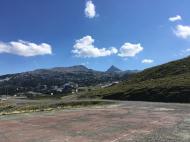
Further information(s) : Parking au pied de la falaise.
Situé au pied de l'ancien tennis de la station de ski de La Pierre Saint Martin.
Situé au pied de l'ancien tennis de la station de ski de La Pierre Saint Martin.
Web site(s) :
http://www.lapierrestmartin.com/InfoliveDocuments/activites-ete/escalade/topo_tennis_droite_mail.pdf
Locations :
Area :
France, Nouvelle-Aquitaine, Pyrénées-Atlantiques (64), Oloron-Sainte-Marie, Arette.
|
|
Latitude : 42° 58' 54" N | Longitude : 0° 45' 2" W | Sexagesimal & Orientation |
|
|
Latitude : 42° 58' 51" N | Longitude : 0° 45' 1" W | Sexagesimal & Orientation |
| More coordinates |
Area added by Cid64

